נהיגה מטורפת
Crazy Drive
BlumSoft IL
בוחרים כלי תחבורה ועולם ומתחילים עם 100 נקודות. כל פגיעה מורידה 10 נקודות, ואיסוף בונוסים מאפשר לצבור ניקוד ללא תקרה. המכשולים נוצרים במרחק שמאפשר תגובה ונשמרת לפחות דרך מילוט אחת. כל הנהיגה היא בתוך משחק דמיוני בלבד.
🚗 מכונית
עיר אינסופית או כבישים ומבנים אמיתיים מתוך OSM; מכשולים מוצמדים לכביש.
✈️ מטוס
שומרים מהירות וגובה, טסים מעל עולם פרוצדורלי או מיקום אמיתי ומגיבים לכלי טיס חוצים. מד הגובה ועזר הרחפן מציגים מרחק והפרש גובה.
🚁 מסוק
שולטים בכיוון ובגובה בעולם פרוצדורלי או אמיתי, עם טיסה נמוכה ומכשולים. החץ מסמן את הרחפן הקרוב ומקל על היירוט.
🚤 סירת מרוץ
מאיצים בין סלעים, סירות וצוללות; במפה אמיתית מתחילים בתוך מים ממופים.
ניקוד, בונוסים ושלבים הוגנים
כל פגיעה במכשול או בסביבה משמיעה נקישה ומורידה בדיוק 10 נקודות; כשהניקוד מגיע ל־0 המשחק מסתיים. פריט אדום מוסיף נקודה ופריט ירוק נדיר מוסיף 5 נקודות, ושניהם משמיעים תרועה. במכונית הפריטים הם כדים, במטוס ובמסוק רחפנים ובסירה דגים. בכלי הטיס מוצג עזר לרחפן הקרוב: חץ שמאלה, ישר או ימינה, מרחק והודעה אם הוא מעל או מתחת. כל שלב הוא 2 ק״מ: בשלב הראשון ניתנות בדיוק 40 הזדמנויות אדומות, 6 ירוקות ו־10 אירועי מכשול. עד שלב 10 נוספים בכל שלב 4 אדומים, ירוק אחד ושני אירועי מכשול. האירועים נקבעים לפי מרחק ולא לפי זמן או FPS, ולכן באותו אתגר ובאותו כלי כל השחקנים מקבלים מכסה זהה. הישג מושווה קודם לפי השלב שהושג ואחר כך לפי שיא הניקוד.
שליטה במחשב
- תנועת עכבר ימינה/שמאלה קובעת את הפנייה. תנועה קדימה/אחורה משנה את המהירות המבוקשת; לאחר עצירת העכבר המהירות נשמרת.
- הכפתור הימני הוא בוסט במכונית ובסירה ועלייה בכלי טיס. הכפתור השמאלי הוא בלם במכונית, ירידה בכלי טיס וטרים חרטום בסירה.
- חלופה: WASD או חצים; רווח/E לפעולה הימנית ו־Shift/Q לפעולה השמאלית.
- P או Esc להשהיה; R להתחלה מחדש; H מחזיר מכונית שירדה מהכביש אל כביש בטוח.
שליטה בטאבלט או בטלפון
- מטים קדימה כדי להעלות את המהירות המבוקשת ואחורה כדי להוריד אותה. כשחוזרים לתנוחת הכיול, המהירות נשמרת. הטיה ימינה/שמאלה היא היגוי ישיר.
- מוצגים רק שני כפתורי פעולה: השמאלי והימני. במטוס ובמסוק הם ירידה ועלייה; במכונית בלימה ובוסט; בסירה טרים חרטום ובוסט.
- לאחר אישור החיישן מופיע מסך כיול מפורש. מחזיקים לרוחב בתנוחה הנוחה ולוחצים „כייל והתחל”. לאחר שינוי תנוחת האחיזה או מעבר לצד השני של המסך, השתמשו בכפתור הכיול הזמין במשחק.
- גרירה אינה פעילה בזמן שחיישן ההטיה עובד. היא מופעלת רק כחלופה לאחר בחירה מפורשת להמשיך ללא חיישן.
- המכונית חופשית לנסוע גם בשול ובשדה, ללא החלשת מנוע או היגוי וללא החזרה אוטומטית. אם רוצים לחזור לכביש, משהים את המשחק ובוחרים „חזרה לכביש”; הניקוד, המרחק והשלב נשמרים.
רגישות ופניות
בתחתית תפריט המשחק נמצא מחוון „רגישות הטיה” בטווח 1–10. רמה 5 שומרת את הרגישות הקודמת: הטיה של 14° נותנת פקודה מלאה. רמה 1 דורשת 22°, ורמה 10 דורשת 8°. המחוון משפיע על ההיגוי ועל שינוי המהירות בהטיה; ההגדרה נשמרת בדפדפן כאשר האחסון זמין. מחוון העכבר נפרד.
במצב המשחק החדש קשת הפנייה של המכונית מתרחבת במהירות גבוהה. בסירה, היגוי ללא תנועה וללא כוח מנוע אינו מסובב את הסירה; כשמתחילים לנוע אפשר לתמרן. אפשר לבחור גם במצב השליטה הקודם. לפתיחת המצב החדש חזרו לקישור הרגיל למשחק.
בחירת אזור משחק
בתפריט „מיפוי אזור” אפשר לבחור חולון, בת ים או ראשון לציון, או לבחור אזור אחר. הגדירו רדיוס של 0.5–5 ק״מ ושמרו אותו. האזורים השמורים נמצאים בדפדפן של המכשיר שבו נוצרו; מחיקת נתוני האתר מוחקת גם אותם. יצירת אזור חדש מחוץ למפות המצורפות דורשת חיבור לרשת. אין חובה למסור את המיקום שלכם: אפשר לבחור עיר או להזין קואורדינטות.
תצוגה וביצועים
במפות העירוניות מופיעים כבישים, מדרכות ומבנים. המשחק מתאים את רמת הפירוט לביצועי המכשיר. אם התנועה אינה חלקה, נסו עולם פשוט יותר וסגרו לשוניות אחרות. מראה הרחובות במשחק אינו כלי ניווט לנסיעה אמיתית.
מתחילים בטלפון או בטאבלט
- פותחים את המשחק בדפדפן ומסובבים את המכשיר לרוחב.
- בוחרים כלי תחבורה. אם בחרתם שליטה בהטיה, מאשרים גישה לחיישני תנועה כאשר הדפדפן מבקש זאת.
- מחזיקים את המכשיר בתנוחה נוחה ולוחצים „כייל והתחל”. הזזה קטנה ימינה ושמאלה עוזרת להכיר את ההיגוי.
- אם ההיגוי אינו מתאים לתנוחה החדשה, מבצעים כיול מחדש. אפשר גם לבחור „המשך ללא הטיה”.
אין תגובה להטיה? בדקו שהרשאת התנועה פעילה. במכשיר ללא חיישן מתאים השתמשו באפשרות השליטה החלופית.
מפות ופרטיות
המפות המקומיות מבוססות על OpenStreetMap. תצוגת Google תלת־ממדית, כאשר היא זמינה באתר, דורשת חיבור לרשת ואינה נשמרת למשחק לא מקוון. „המיקום שלי” מבקש הרשאת מיקום רק לאחר לחיצה. אפשר לשחק גם בלי לאשר אותה. מידע נוסף נמצא במדיניות הפרטיות.
Choose a vehicle and world and begin with 100 points. Every impact costs 10 points, while collectibles let the score grow without a cap. Hazards are placed far enough ahead to allow a reaction, with at least one escape route. All driving takes place in a fictional game world.
🚗 Car
Use the endless city or real OSM roads and buildings, with road-snapped hazards.
✈️ Plane
Manage speed and altitude over a procedural or selected real location. The altimeter and drone guide show range and height difference.
🚁 Helicopter
Control direction and altitude in procedural terrain or a real mapped location. The guide points toward the nearest drone.
🚤 Speedboat
Race past rocks, boats and submarines; real-map mode starts in mapped water.
Score, collectibles and fair stages
Every obstacle or environment impact plays a knock and removes exactly 10 points; the run ends at 0. A red collectible adds 1 point and a rarer green one adds 5, both with a short fanfare. Cars collect pots, planes and helicopters collect drones, and boats collect fish. Aircraft also show a guide to the nearest drone: left, ahead or right, its range, and whether it is above or below. Every stage covers 2 km: stage one offers exactly 40 red opportunities, 6 green opportunities and 10 hazard events. Through stage 10, each new stage adds 4 red items, 1 green item and 2 hazard events. Events are scheduled by travelled distance rather than time or FPS, giving players the same allowance in the same vehicle and daily challenge. Results are compared by stage reached first, then peak score.
Computer controls
- Move the mouse sideways for direct steering. Forward/back movement changes a latched target speed that remains after the mouse stops.
- The right button is boost for car/boat and climb for aircraft. The left button is car brake, aircraft descent or boat bow trim.
- Alternative: WASD/arrows; Space/E is the right action and Shift/Q the left action.
- P or Escape pauses; R restarts; H returns an off-road car to a safe road.
Tablet and phone controls
- Tilt forward/back to change the latched target speed; return to the calibrated pose to keep that speed. Side tilt is direct steering.
- Exactly two action buttons are shown: car brake/boost, aircraft descend/climb, or boat bow trim/boost.
- After sensor permission, hold the device comfortably in landscape and calibrate. After changing your grip or switching to the opposite landscape orientation, use the in-game recalibration button.
- Left-side drag is disabled while tilt works and is enabled only after explicitly continuing without a sensor.
- The car may drive on roads, shoulders or fields with the same engine and steering authority. Nothing returns it automatically. To return voluntarily, pause and select “Return to road”; score, distance and stage are preserved.
Sensitivity and turning
The “Tilt sensitivity” slider at the bottom of the game menu ranges from 1 to 10. Level 5 retains the previous response: 14° gives full input. Level 1 requires 22°, and level 10 requires 8°. It affects steering and tilt speed commands; the setting is remembered when browser storage is available. Mouse sensitivity has a separate slider.
In the new game mode, the car follows a wider turning arc at high speed. A stationary boat with no engine power will not rotate just from steering; applying power enables manoeuvring. You can also choose the previous control mode. Use the normal game link to return to the new mode.
Choose a play area
Open “Map an area” and choose Holon, Bat Yam, Rishon LeZion or another location. Select a 0.5–5 km radius and save the area. Saved areas belong to this browser on this device; clearing site data removes them. Creating an area outside the bundled maps requires an internet connection. Sharing your location is optional: choose a city or enter coordinates instead.
Display and performance
City maps show roads, pavements and buildings. The game adjusts detail to device performance. If movement is uneven, try a simpler world and close other tabs. The game is not a navigation tool for real driving.
Start on a phone or tablet
- Open the game in your browser and hold the device in landscape.
- Choose a vehicle. For tilt controls, allow motion access when the browser asks.
- Hold the device comfortably and select “Calibrate and start”. Use small side movements to learn the steering.
- Recalibrate if your holding position changes, or choose “Continue without tilt”.
If tilt does not respond, check motion permission or select the alternative controls.
Maps and privacy
Local maps use OpenStreetMap data. Google 3D imagery, when available on the site, needs an internet connection and is not saved for offline play. “My location” asks for location access only after a click; you can play without granting it. See the privacy policy.
דוגמת ניקוד במשחק
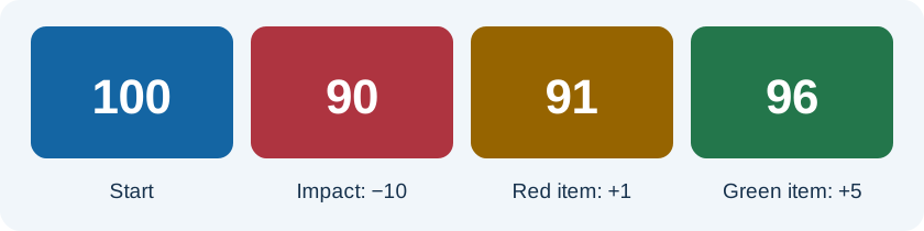
מתחילים עם 100 נקודות. פגיעה אחת מורידה את הניקוד ל־90. איסוף פריט אדום מוסיף נקודה ומביא ל־91, ופריט ירוק מוסיף 5 ומביא ל־96. האיור מציג רצף לדוגמה, ולא מסלול שחייבים לבצע. הכל מתרחש במשחק דמיוני בלבד.
להכיר את השליטה לפני שמתקדמים
התחילו במהירות נוחה והכירו את שני כפתורי הפעולה של כלי התחבורה שבחרתם. במכשיר נייד כיילו בתנוחה שבה תשחקו. אם שיניתם את צורת האחיזה, עצרו וכיילו מחדש לפני ההמשך.
An example score sequence
Start with 100 points. One impact reduces the score to 90. A red item adds one point for 91, and a green item adds five for 96. The illustration is an example sequence, not a required route. Everything takes place in a fictional game.
Learn the controls first
Begin at a comfortable speed and learn the two action buttons for your vehicle. On mobile, calibrate in your playing position. If you change your grip, pause and recalibrate before continuing.